
I found these on a website called Britain from Above...they claim everything!
http://www.britainfromabove.org.uk/asea ... h=Donabate
Where was or where is Turvey House located?
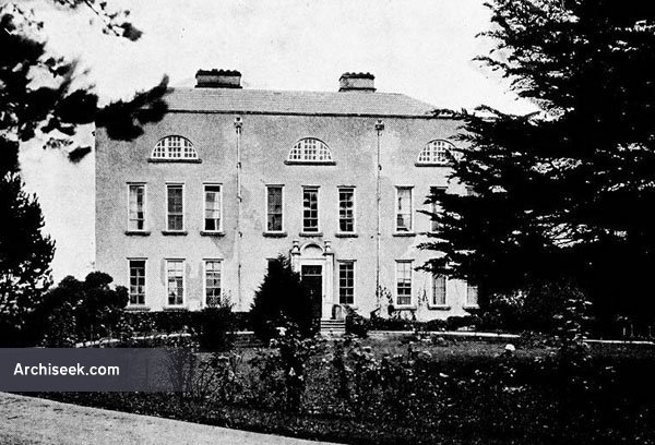
Aerial pictures of Turvey House
-
Mr. Stupid
- Posts: 777
- Joined: 15 Oct 2012, 11:54
- Has thanked: 4 times
- Been thanked: 25 times
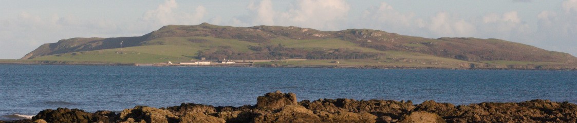
I think that is the house you can see from the other side of the Estuary.
Its the house that was on Turvey Golf course demolished with some controversy in 1987. this was brought up in the Flood tribunal.
Extract of report on tribunal below:
The controversial demolition of a 16th century listed building in North County Dublin has been revisited by the Flood Tribunal, which resumed public hearings today. Turvey House in Donabate was owned by the Murphy Group in 1987, when its demolition caused public outcry. Today the Tribunal has been hearing evidence from the Dublin County Council official who signed the demolition order. Tom Doherty has said that the then Assistant City and County Manager, George Redmond, had no involvement in his decision.
-
diggerbarnes
- Posts: 412
- Joined: 18 Oct 2012, 10:20
- Has thanked: 2 times
- Been thanked: 12 times
It doesn't exist any more. I believe the story goes that a gobshite developer razed it to the ground one night despite not having permission to do so. It's regarded as a crime against architecture as it had unique features.
-
diggerbarnes
- Posts: 412
- Joined: 18 Oct 2012, 10:20
- Has thanked: 2 times
- Been thanked: 12 times
He should have been made rebuild it brick by brick. It's been done before.
Wow, great Find Austy. Yes, it's a terrible pity that it was knocked down. I believe not long before it was knocked down it was looted and many of the internal features were either damaged or stolen. We can't keep all such buildings in public ownership and open to the public, but I'm sure there are people willing to purchase, live in and preserve them such as with Seafield House.
We tend to protect such structures in Ireland, but do little to preserve them. Stella's castle in Portrane is one such example. I fear what will happen to St. Ita's as it's difficult to see another use for the old hospital buildings which are also "protected".
We tend to protect such structures in Ireland, but do little to preserve them. Stella's castle in Portrane is one such example. I fear what will happen to St. Ita's as it's difficult to see another use for the old hospital buildings which are also "protected".
Regards,
Ken.
Ken.
No, that's Seafield House that's in private ownership.Mr. Stupid wrote:I think that is the house you can see from the other side of the Estuary.
http://www.buildingsofireland.ie/niah/s ... o=11336024
Regards,
Ken.
Ken.
-
Quello Serio
- Posts: 150
- Joined: 26 Nov 2012, 22:07
- Been thanked: 6 times
I think that was one ugly house. They should have stuck the roof on and gone home when the first floor was finished.
A great find there Austy.
Would be great if there could be any old photos of Donabate and Portrane recorded online somewhere.
The Turvey House aeriel pictures appear to be of two separate houses taken 1 year apart. I wonder where the older looking house would be, if still in existence.
The one that was demolished I calculate to being around here;
http://tinyurl.com/kak7skh
Its a sin to demolish a house like the first, but the second.....
I am interested in the history and its future of where I live and have grown to love.
Last edited by jayflame on 19 Oct 2014, 15:26, edited 1 time in total.
OK, amended link and tested in all browsers, it works.Ken wrote:You're link doesn't appear to be working Jayflame.
If it doesn't for whatever reason, paste the following into Google Maps search
53°29'48.8"N 6°10'34.0"W
Hi Jayflame,
Take a look at the map on www.osi.ie. You can superimpose the current map over the old maps. The location of Turvey House was just behind where the Turvey golf club house is today.
You're close on your map, but the OSI map will show you exactly.
Take a look at the map on www.osi.ie. You can superimpose the current map over the old maps. The location of Turvey House was just behind where the Turvey golf club house is today.
You're close on your map, but the OSI map will show you exactly.
Regards,
Ken.
Ken.
I think I walked past where the house is only today. If you take the walk towards the estuary hide from the allotments you will see a field on the right hand side that's artificially way higher than the surrounding fields, I wondered what it was at the time and coincedentally came across this thread today. So I reckon the remains of the house are buried under that pile?
The house originally stood just behind where the old Turvey Golf Club house is today. You can see its exact location compared to the club house on the OSI map linked in my last post.
Here's a snip fro the map. The grey building at the front is the current club house. The buildings in black at the rear are where Turvey House stood.
Here's a snip fro the map. The grey building at the front is the current club house. The buildings in black at the rear are where Turvey House stood.
Regards,
Ken.
Ken.